- Learn about olive trees, regarded as sacred by the ancient Greeks, a symbol of wisdom and peace in a land of turbulent history. Some of the oldest trees are over 1,000 years old!
- For bird watchers there are soaring eagles and peregrine falcons among the many rare species
- Pick bunches of fragrant herbs and discover the countless exotic wild flowers
- Woods and the protected olive grove allow for great walks and cycle rides in magnificent surroundings
- Join in the harvest between September and January in the olive grove, find out all about “olives”, how they are prepared and how olive oil is made.
Waterfalls of Drimona

On leaving Rovies towards Osios David monastery and after passing the villages Paleohori, Damia, Kalamoudi, Drimona, we reach the waterfalls.
A wooden board welcomes us. A downhill path takes us to the first waterfall in 10 minutes.
The sound of the water is captivating and the beauty of the surroundings is enchanting. The waterholes invite you to paddle in the crystal waters and to swim.
After the catarract the path continues and in 5 minute you are back on the main road. Wooden benches will offer you rest.
Trail on mount Xiron- Xiron Oros
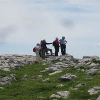
The path to the top of the mountain, of 990 meters height starts with a few steps across from the wooden cabin placed in the parking area of the waterfalls. The first part of the trail is easy but after a while it becomes uphill.
The fir forest is very dense while there are also oak and maple trees among them.
Red-white metal signs on the trees show the way.
In the spring you will see thousands of wild flowers, in the summer you will enjoy the coolness under the shade of the trees and in winter you will test your endurance walking in the snow.
The panoramic view from the peak encompasses the ups and downs of Central Evia, the islands of Skiathos and Skopelos and, if it is a very clear day, you can see Mount Athos.
The whole trek is 3 hours.
Kalamoudi-Retsinolakos route
It is a downhill road, about 6 km long. However, one member of the party will have to see only pictures of the walk as he/she will have to bring the car to the end of the route, unless the whole party are prepared to walk back (another 6 km but uphill this time).
We start from Kalamoudi, turning right before the church. The road is paved with cement at the start and then becomes a downhill dirt road.
At about 100 meters we find a three-way crossing. We go straight on. After about 400 meters there is a second three-way crossing where we turn left. After another 400 meters at a spot with young olive trees, we turn right. After 3,2 km we meet a small water-hole with reeds. If we are lucky, we will see water-turtles.
After 2 more km we reach the Retsinolakos village. A narrow paved road of 2,5 km takes us to the Limni-Rovies road near the “Bella Vista” restaurant where we hope the car is waiting for us.
Trail of Papades
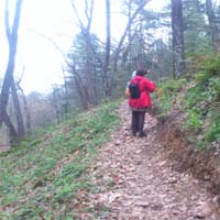
To forget your worries, there is nothing more effective, than a three-hour walk in a forest trail.
On the road from Papades to Vasilika turn left towards” Dasiko Horio” (Forest Village).
The forest path starts right across from the entrance to Dasiko Horio and it is marked all the way by the Forest Department.
The beginning of the trail is paved and you certainly cannot miss it.
Along the way you will find a map so that you can plan your walk. The trail will take you through chestnut trees (many trees bear their names on small labels), along ravines to the top of the hill and will take you back to the place where you have left your car.
Do not leave anything behind but your footprints, do not take anything except pictures.
Take notice of the wild flowers. Take deep breath and enjoy.
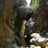
Nileas Gorge (Arapis or Boulovinena Gorge)
Best for the summer or early fall.
From the village Keramia direction Agia Anna and at about 3 km from the main road, you will meet the start of the trail on your left ( in winter we suggest that you do the route on foot as it becomes very muddy). After about 1 km on a dirt road you will reach a flat area where you can park your car, if you have driven it up to here. Small sign-posts will guide you towards the river bed of Nileas, otherwise it is a bit hard to find your way.
For 20 min you will be walking in a forest of all shades of green. Here and there on the way you will glimpse the river from up high.
Entering the gorge you will be impressed. Large fallen boulders create a tunnel. You will have to wear a swim-suit as, at a few spots, you may need to get into the water up to your waist or may even have to swim. You will need about 2 hours to reach the bridge of Amelantes.
Keep in mind that you will have to return the same way and save your strength, or do not go the whole route.
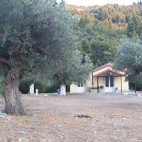
Ancient olive trees
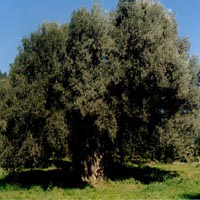
A part of the ancient olive grove, as described by Stravon (1 A.D.) in his work “Geographica”, still exists within the olive groves of Rovies. The trees could even be 2000 years old. They are monument of nature.
One of the trees is named “Nymphe”- Bride. To embers the trunk of this tree ten grown-ups holding hands are needed.
Strange shapes and figures are visible on the trunk depending on the position of the sun.
These trees are still producing fruit.
You will find them walking along the beach from Rovies, over the river and turning right into a dirt road. At the end of the road to your right you will see the old olive trees.
Following the route of the mining of magnesite
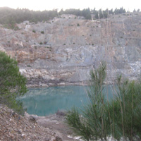
You will start from Limni towards the convent of Galataki. On the way you will observe remnants of the old furnaces where the processed the magnesite. You will then see the storage building and the tall chimney (now housing the Kaminos Resort). Further on there is the old trade house and in the sea the pier and the bases for two cranes which where used to load the magnesite and unload coal from England. Before you reach the restaurant Astron you have to leave the paved road and continue on a dirt road. Here were the tracks for the old little train which transported the magnesite up to the early 1900’s because later there was aerial transportation. After about 7 km –slightly inclined (only 4%) easy walking path among pine trees and wild berry bushes you will reach the first lake, created by the excavation of magnesite.
Naked mountains, strange coloring and water. The landscape is out of this world.